The Shortcut That Wasn't
or
Erin Brockovich Revisited
As we left Canyonlands National Park in southeastern Utah, we decided to take a more scenic route to Grand Junction in western Colorado, our planned stop for the evening. We had mapped it out on Street Atlas 7 and most of the roads were US/state roads with speed limits up to 65 MPH, so it seemed like a viable route. A screen capture of part of this route is shown below.
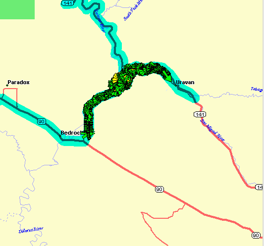
A map showing part of our trip
We progressed along the road viewing the wonderful panoramic cliffs and canyons of southern Utah, at times driving just feet from the vertical face. Part of the way through the route we noticed a strange switchback, and when we looked at the map in more detail it appeared to be a shortcut from one US route to another following a river. The route was called Y-11. Going 65 MPH we blinked and passed a small road on our left. Glimpsing the small street sign (there was no larger route sign), we thought it read Y-11 (River Road). So, a quarter mile down the road we managed to pull off and turn around to head back to our designated route. When we turned into the road, it was apparent that it was a dirt road; however it seemed relatively well-maintained and certainly passable in a standard passenger car (our Lexus). We could travel along comfortably at 25-30 MPH, leaving a cloud of dust in our wake. Fortunately, no one was in front of us nor behind us, and we passed no one along the route.
At many points you could see where the road was washed out and re-graded, but it remained smooth so we decided to continue on our adventure. On the map, it appeared that this would just be a several mile diversion to save us over 30 miles of highway driving. And the panoramic views seemed well worth the trade off. As we proceeded down the road, our talking GPS system said that we had another 12 miles to go before rejoining our main route. We didn't expect it to be that far, but the road was quite passable so we continued. The road paralleled a meandering river, at times just feet from its banks, although 20 feet above the level of the water. At some places we certainly wouldn't want to meet another vehicle, given the only vehicle sane enough to drive on this road would probably be a four wheel drive truck barreling along around the curves at 45 MPH. (see below)
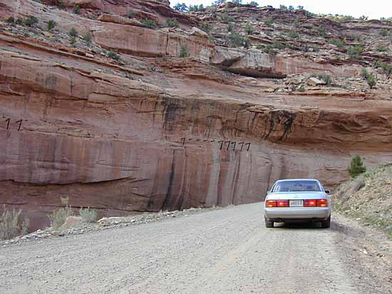
Narrow, winding road
About halfway in, we passed a strange, large, rusted tank. It must have been 8 feet in diameter and 50 feet long, precariously perched up on the slopes. We thought it was strange that someone would dump such a large tank up on the embankment. If they wanted to ditch it, it seemed like they could have done so miles before. (see below)
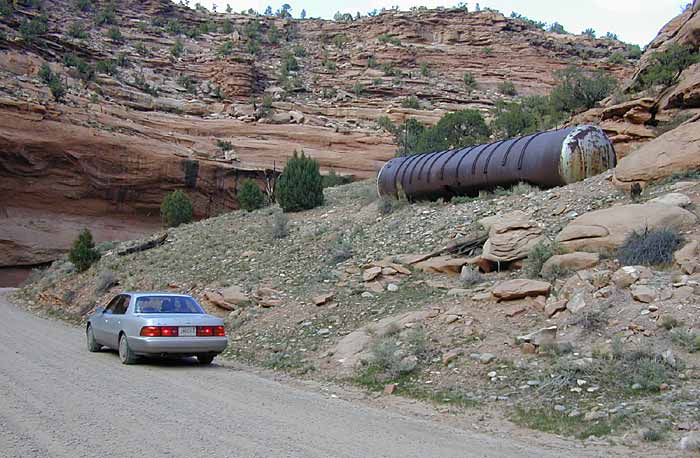
Rusted tank on the hillside
Driving a little farther, on the opposite side of the river which we were paralleling, was a near vertical cliff easily several hundred feet tall. We saw the remains of some large timbers sticking out perpendicular from these cliffs. (see below)
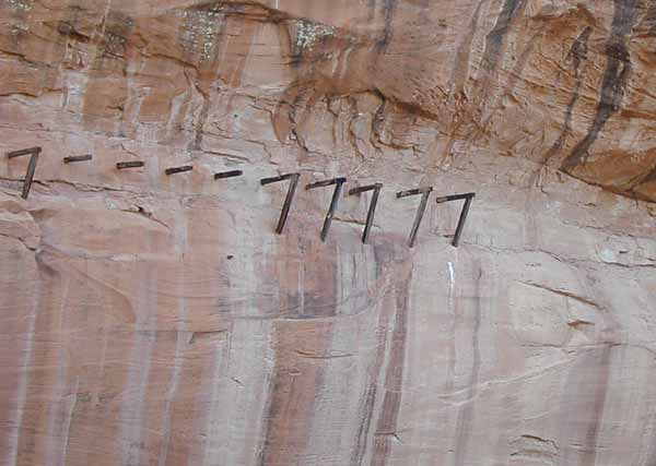
Large timbers on the side of the cliffs
Some had diagonal bracing back to the face. We puzzled at what these might have been and thought it was a mighty strange place to put a trail to avoid going over the upper part of the canyon. As we continued down the road, these timbers were more prevalent and at times you could see a row of 20 or 30 of them. Many were broken and just dangling across the face of the cliff, but some were still in their original configuration sticking out perpendicular to the cliff face. We continued to find these intriguing, puzzling objects. (see below)
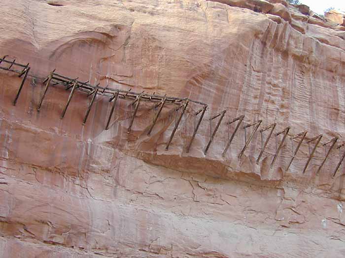
Row of timbers with bracing out from the side of the cliff
Further down the road we noticed 2 lengths of white PVC pipe haphazardly stuck on some bushes 10 feet above the road. (see below)
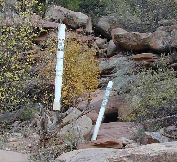
PVC pipe markers
These appeared to be some sort of informal mining claim; however they were dated 1995, so this wasn't any ancient archeological discovery that we had found. (see below)
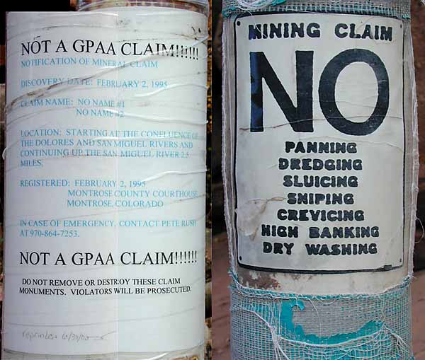
Detail of labeling on the two pipes
We couldn't find the acronym GPAA with the acronym finder on the web, but a Google search resulted in a web site called www.goldprospectors.org. The introduction on this page is quoted below:
"The Gold Prospectors Association (GPAA) was founded in 1968 to preserve and promote the great heritage of the North American Prospector. The GPAA was also dedicated to providing a platform for the exchange of information, presenting an organized voice for recreational and professional prospectors and helping it's members find more gold."
"Today, the GPAA has become the worlds largest prospecting organization, but our goals haven't changed one bit. Through television, the internet and print media, the GPAA today provides more information and is a more effective organized voice that ever before. GPAA programs provide places to go, local support, free information service and much more."
We continued driving. Every few minutes we pressed the button on our GPS tracker to tell us how much further on this dirt road we had left to drive... 5 miles... 4 miles... 3 miles... the end was near and we were confident that we could make it!
At this point, there was a fence paralleling us on one side of the road with the river on the other side. We came to a point where literally we expected the fence to cross the road and make it impassable. Oh, well, it's only another 12 miles to reverse our route and get out. We got in...we could get out...however, as we approached the fence, the road took a sharp turn to the left and it was clear for now that we could proceed unimpeded.
Scanning ahead, we could see the road that we wanted to join on the other side of the river to complete our "shortcut". We saw an old bridge crossing the river that would probably connect our road to the new road. Nearing the bridge it was clear that it was not in service and large rocks were placed on either side to block any attempt at passage. Undaunted, we figured there must be another bridge further down. After all, this was an interconnecting road that was shown on our map.
We had been watching the cliffs on the opposite side of the road ever since we had spotted the strange timbers. Now, the cliffs had subsided and there was maybe a 30 foot embankment. Along the embankment we could see a metal fence and what appeared to be a strange hose maybe 8-12 inches in diameter kept in place now and then with sandbags. Another puzzling "whats-it", but it was nowhere near as interesting as the timbers we had seen, so we didn't think much of it.
Soon we could see a second bridge crossing the river, and we were sure this would be our ticket to freedom, or at least to get off this dirt road and onto something paved. Once again, looking straight ahead, we saw gates blocking the road. This appeared to be a more formidable obstacle than a mere fence. Upon approaching the gates, we realized the road made a hard left turn and in fact we could proceed and cross the bridge. However, at and around the gates there were numerous signs reading "no trespassing", "hard hat area", "danger of radioactive material ahead" and other such warnings. (see below)
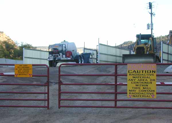
Caution: Radioactive Material sign
This struck us as a little strange, as you don't typically drive down your back country road and meet up with signs proclaiming "radioactive material ahead". Of course, we needed some pictures to document this, so we snapped a few quickly. If you remember Julia Roberts in Erin Brockovich, you can understand what it feels like. Take a few pictures and get the hell out of there!
With our destination road in sight, we passed a parking lot full of heavy equipment and half a dozen pickup trucks. We saw some men with hard hats milling around. We thought we might stop and ask them about the strange timbers, but we decided we had better just continue along hoping that they wouldn't think tourists with Massachusetts license plates driving around on this dirt road were anything unusual. As we were about to turn onto the main road, we saw a sign at the entrance that announced "Umetco Minerals Corporation". Also, we noted a small sign confirming to us that we had endured 16 miles on that dirt road to reach the connecting road on the other side. (see below)
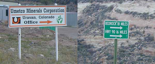
Signs we saw on the way out
We were sure that our adventure was over now that we were back on the paved road with a 55 MPH speed limit; however, less than a quarter mile down the road, between the road and the river, we noticed large plastic-lined shallow depressions with strange markers placed in them. Again, out came the camera to take a few more quick shots. (see below)
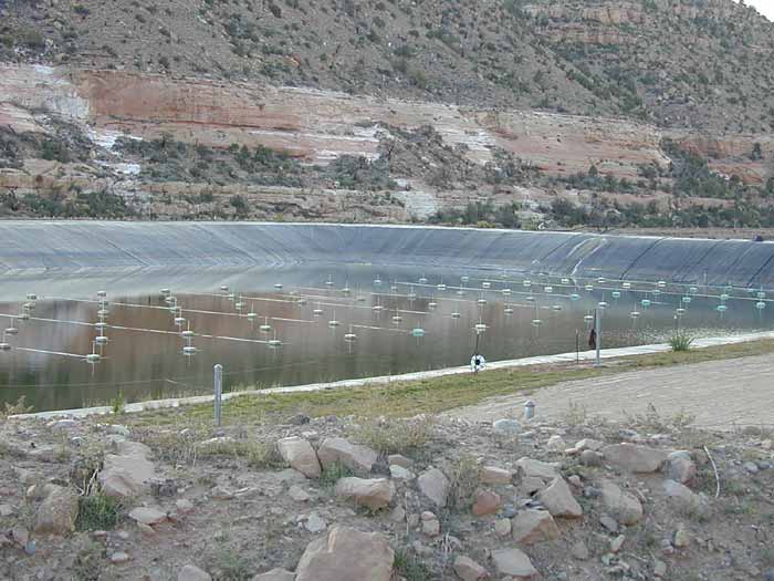
Ponds lined with plastic
Definitely felt like Erin Brockovich again, stumbling on some radioactive waste water. For all we knew, it was radioactive. We recalled from the movie discussions of various waste holding ponds and the comment that some of those ponds were unlined. We felt better knowing these ponds were lined, but it was still an eerie sight and we really didn't know what was in them.
Continuing along, these ponds and our thoughts about them waned. We stopped at an overlook to look over where we had been. (see below)
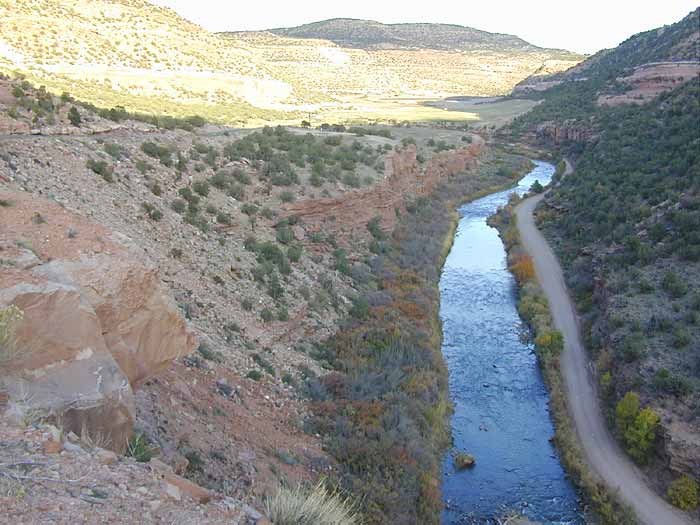
Overlook showing the dirt road we had traveled, to the right of the river
At the next overlook, we saw a sign for a historic marker. Not knowing the significance of it, we had to stop and take a look. Voila! The secret of the timbers was revealed! They were designed to be an old aqueduct (flume) for some now defunct mining operation. (see below)
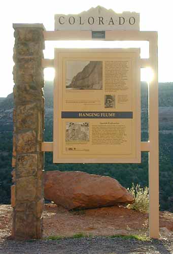
Historic marker explaining the Hanging Flume
An old photo and some discussion about the use of this flume could be read from the sign. (see below)
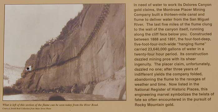
Description of the "hanging flume" built between 1888 and 1891
We did note that on one section of the text it discussed mining materials such as copper, radium, vanadium and uranium. Yup, we could certainly believe some of that stuff was or still is radioactive. (see below)
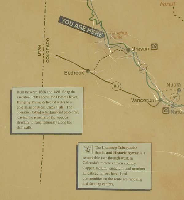
Details of the map and additional description
We had passed the mysterious Area 51 and had solved the puzzle of the timbers in the rocks. Now, we only had a short 100 mile drive on paved roads to our next destination, Grand Junction, right on Interstate 70!
Although this trip along the back road was interesting and potentially educating, we would think twice before choosing this route again; however, if any of you readers would like a detailed map and itinerary we would be glad to provide you with one. A four wheel drive vehicle is not required.
We are writing this on our way to Grand Junction while the memories of our adventure are fresh in our minds. Grand Junction is a mere 44 miles away and we have already driven 490 miles on our tank of gas. The low gas light isn't on yet, and under the best conditions we can drive about 550 miles on a tank. We are hoping that we are driving under the best conditions for the next 44 miles :-) If there is a significant delay in getting to Grand Junction, you can bet we have run out of gas. There are virtually no houses around and the last two towns we passed through seemed like ghost towns. The buildings with gas station logos were nothing but boarded up windows and out of order pumps. Stay tuned...
The GPS chimed 6200 feet and we saw a road sign "steep grade next 5 miles". In the distance we saw the lights of Grand Junction and figured we could nearly coast down the mountain if we were desperate. 5200 feet and still descending... 4600... 4200...
We made it to a gas station at about 7:30 pm. The car "only" took 19.5 gallons (tank holds 22.5 gallons) and we had driven 528 miles.
Bill & Jill
PS: if we knew this was going to be such an interesting encounter we would have taken more pictures and notes along the way!